0

Powder Day

We received 6 to 12 inches of new snow last night and this morning.  The snowfall that we received was an upslope snow event.

NoaaThe National Weather Service defines an upslope snow event as:

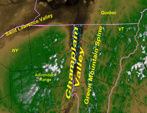
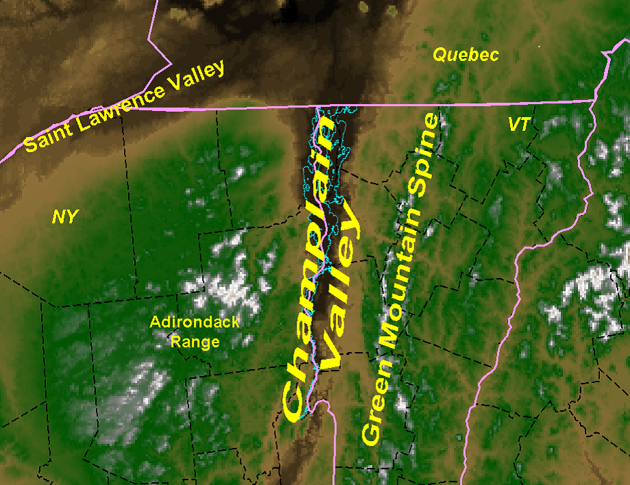
These are highly localized, possibly high impact events that affect the region. Upslope precipitation, in general, is produced by cool moist air being forced up the mountain slopes, and in this study, on northerly to westerly winds. Depending on the details of each event, impacts can range from only a few inches along the peaks of the Green Mountains to a highway-closing 1 to 3 foot snowstorm along the western slopes of the Green Mountains and even into the Champlain Valley. One of the main factors in these events is the terrain of Vermont, as shown in Figure 1. The Green Mountains, with peaks as high as 4395 feet (Mount Mansfield) run primarily north to south through the central portion of the state and are one of the main contributors to upslope snowfall in the state. Research by: Michael Muccilli, Meteorologist, NWS Burlington, VT

Figure1Amazing conditions

Sterling Mountain is 100 percent open! This weekend we plan to have top to bottom skiing and riding on all 3 mountains with 4 lifts operating, the Madonna I Lift, the Sterling Lift, Mogul Mouse’s Magic Lift, and Sir Henry’s Glider.

OLYMPUS DIGITAL CAMERA

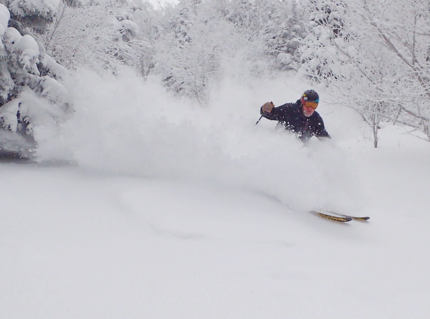
Snow Sport University Ski Instructor Matt McCawley goes deep on Upper Exhibition

OLYMPUS DIGITAL CAMERA

Nemo floating down Upper Exhibition

0

Snowfall and colder temperatures this week

NoaaThe forecast from the National Weather Service

Today
Rain showers likely before 11:00 am, then rain and snow showers likely between 11:00 am and noon, then snow showers after noon. Chance of precipitation is 80%. Total daytime snow accumulation of 1 to 3 inches possible.
Tonight
Snow showers likely, mainly before 3:00 am. Cloudy, with a low around 11.  Chance of precipitation is 60%. New snow accumulation of 2 to 4 inches possible.
Tuesday
A 40 percent chance of snow showers, mainly before 1:00 pm. Mostly cloudy, with a high near 15.  New snow accumulation of 1 to 3 inches possible.
Tuesday Night
Mostly cloudy, with a low around 8.
Wednesday
Mostly sunny, with a high near 21.
Wednesday Night
Mostly cloudy, with a low around 16.
Thursday
A 40 percent chance of snow showers after 7:00 am. Mostly cloudy, with a high near 26.
Thursday Night
Snow showers. Low around 9.  Chance of precipitation is 80%.
Friday
A 50 percent chance of snow showers. Mostly cloudy and cold, with a high near 10.

Lifts and Trails

Today we have the Sterling Lift and Sir Henry’s Glider operating. We have 32 trails open with average base depths of 14 to 48 inches. Snow surfaces are variable and machine groomed. 8 trails have been groomed for today, that’s 30 acres of freshly groomed terrain.

Snowmaking

The temperature will be falling this afternoon and this evening. Our snowmakers are busy getting ready to head to Madonna Mountain tonight. We plan to make snow on Lower FIS and Mulcahy’s Link.

0

Snowfall totals have been increased

header_noaaThe National Weather Service has issued a Winter Weather Advisory

Today
Snow likely, mainly after 4:oo pm. Patchy fog before 10:00 am. Otherwise, cloudy, with a high near 33.  Chance of precipitation is 70%. Total daytime snow accumulation of less than one inch possible.
Tonight
Snow. Low around 21.  Chance of precipitation is 100%. New snow accumulation of 3 to 7 inches possible.
Tuesday
Snow before 1:00 pm, then snow showers likely after 1:00 pm. High near 31.  Chance of precipitation is 100%. New snow accumulation of 3 to 5 inches possible.
Tuesday Night
Snow showers likely. Cloudy, with a low around 17. Chance of precipitation is 70%. New snow accumulation of 1 to 3 inches possible.
Wednesday
Snow showers likely. Cloudy, with a high near 29. Chance of precipitation is 70%. New snow accumulation of 2 to 4 inches possible.
0

Snow in the forecast early in the week

header_noaaThe National Weather Service is calling for mixed precipitation today with colder temperatures and snow in the forecast for this week. We plan to have the Madonna I lift operating next weekend weather permitting. Snowmaking will resume with the colder temperatures this week also. Today we have the Sterling lift and Sir Henry’s Magic Carpet operating with 31 trails open. 9 trails have been groomed for today, including Smugglers’ Alley for a grand total of 32 acres of freshly groomed terrain.
Monday
Snow likely, mainly after 2:00 pm. Cloudy, with a high near 34. Windy, with a south wind 16 to 26 mph increasing to 27 to 37 mph in the afternoon. Chance of precipitation is 70%. New snow accumulation of less than one inch possible.
Monday Night
Snow. Low around 26. Very windy, with a southeast wind 50 to 55 mph, with gusts as high as 70 mph. Chance of precipitation is 100%. New snow accumulation of 3 to 5 inches possible.
Tuesday
Snow. High near 32. Windy, with an east wind 23 to 33 mph becoming west 6 to 11 mph. Winds could gust as high as 43 mph. Chance of precipitation is 100%. New snow accumulation of 2 to 4 inches possible.